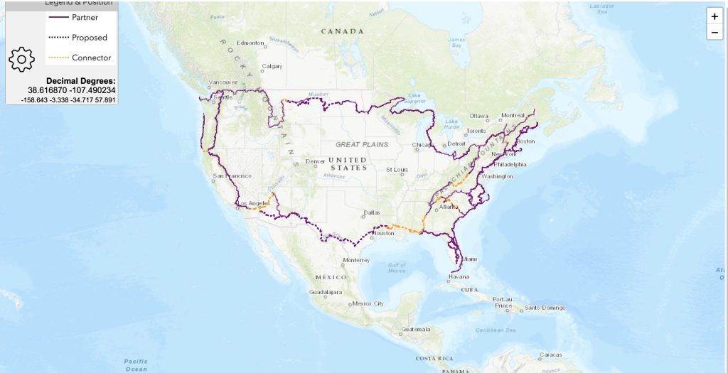
Building the Interactive map
Trail geometry for existing National Trails was typically obtained from the primary website for that trail. Occasionally the Open Street Maps Waymarked Trails site was used. The trails were connected using Rue’s GPS track where it made sense, but adjustments were made based on his post-hike experience. In some cases, a “Connector Trail” was created to link up sections using a planning tool called “Komoot” which allowed us to export the connector geometry. Various tweaks and edits followed based upon feedback from Rue. We had quite a few assists from folks (see Map Acknowledgements) and once the initial geometry was stable an interactive web map was completed with their help. GPX files for download will be coming soon.
Map Acknowledgements:
Trail Geometry – We would like to thank the following contributors for their contributions to the APT Trail Geometry.
- The trail geometry wouldn’t be possible without the existing geometry for National trails such as the Pacific Crest Trail, Pacific Northwest Trail, Florida Trail, North Country Trail, Great Eastern Trail, and many others. Our thanks go to the contributors to those trails.
- Additionally, thanks to Rue McKenrick for his invaluable GPS track of the APT route.
- Thanks to Eoin Hamilton of Hiiker for his advice and support.
- Thanks to the contributors and editors of Open Street Map (OSM) which was the base geometry and related information for our connector routes. We used the Komoot app to create those connector hiking routes which uses OSM data.
- Thanks also to the creators and contributors for the open source QGIS Geographic Information System which was used to manage and edit the geometry in preparation for publishing the interactive map.
- Tim McGrath was the Geographer and Editor for the trail data.
Web Map App – We would like to thank the following folks for their help and contributions to getting the interactive web map up and running.
- Scott Parks of postholer.com for his huge software engineering contribution and coding guidance to the Leaflet map.
- Rue McKenrick reviewed the geometry and provided partner trail information and other routing advice.
- Jim Meacham for his advice on map styling and cartography.
- The creators and contributors to the open-source Leaflet mapping code.
- The creators and contributors of the Flatgeobuf geographic data format.
- Tim McGrath was the Geographer and other software engineer.